Many industries are making the most out of the Geographic Information systems. When it comes to an important constituent engagement, this geographic location intelligence can help in improving voter outreach. In a pandemic situation like now, the US government is trying to support its citizens by converting useful location information into user consumable data.
The local and state government’s election departments and political bodies are searching for ways to improve voter participation and involve voters who are detached from the political process. Considering the importance of location intelligence in the US elections, it is crucial to make maps that provide the users with satisfactory results and deliver an enhanced user experience.
Instead of the political bodies and election committee spending weeks and months obtaining data to sustain campaigns, the data can be collected and handled by the Geographic Information System (GIS) makes it handy for the users. With GIS, one could conveniently tap into a single authoritative source and render usable software and interactive maps that the voters expect. Without coding or depending on others, they could generate and retain the information items needed to promote campaigns, educate people, and keep the media and other stakeholders updated.
Benefits Of Using GIS In US Elections
With GIS, position information is integrated into everything you’re doing. This ensures that you can develop information products and help any part of the election process, from planning to election day activities, to voter participation.
- Mapping and visualizing
- Field Mobilization
- Constituent Engagement
- Data Management
- Analytics
- Design & Planning
- Decision support and monitoring
- Sharing and Collaboration
A Location Strategy for Elections
The state and city bodies are managing voting in several respects. For others, it is a year-round endeavor to campaign for and organizes polls. For some, much work is focused around the weeks leading up to and following the polls.
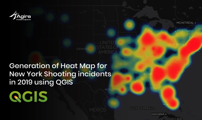
To prove the efficiency of the intelligent maps, our top-notch GIS experts have polt some point features in New Jersey and Texas 2 County. We have also uploaded the map in the QGIS cloud similar to web mapping to make the maps more accessible.
Check out this link that opens the Google pace mark. Also, click on any location to fetch all the essential information.
Click here to check out the live GIS Intelligent Maps with useful election information
1. Mobilizing the Voting Experience
Modern polling site search applications should be easy to use and offer accurate statistics from reputable sources, including an interactive map that is maintained and accepted by the organization. These applications offer driving directions based on real-time traffic and approximate waiting times for voting places. The end-user can tap the map to locate the starting location, use the location of the computer, or enter an address. Detailed information on the site of the polling place and the turn-by-turn directions are provided.
2. Real-time Election Results
Election day audiences are stuck to their mobile screens to news outlets and social media. They want to watch the direction the polls are going and, finally, to see the outcome. Most of this information is gathered and compiled by city councils as ballots are counted. People, media, and candidates want the right to access credible sources of knowledge. They ought to be able to drill on the chart to see if the findings will affect them. The election results app is an authoritative source of information on approximate real-time elections anywhere the end-user is, no matter what platform they use.
3. Constituent Engagement for Elections
The engagement of electors is a common experience. Local governments enhance this experience through open dialogue and a spirit of cooperation. Help voters figure out where they need to go on polling day or early voting, and how to get there.
- Locate early voting centers
- Find election representatives
4. Sharing Election Information
The presence of electors is a shared experience. Local communities strengthen this experience through open discussion and a sense of collaboration. Help people find out where they ought to go on the day of polls or early voting, and how to get there.
5. Election Analytics
Segmentation is based on the theory that people search and live close to others. It has the same preferences, habits, and activities. If there is a population segmented by income, schooling, jobs, and lifestyle, the variations in their tastes are becoming more evident.
- Analyze your community
- Identify and Reach Voters
6. Redistricting for Elections
If the redistricting process will still entail disputes, State and city agencies have learned to deliver unmatched facilities, and access to all parties, including residents, is the secret to the clarity of the redistricting process.
Wherever you are in the election process, you should start developing your location plan. Ready-to-use charts and software help you get moving easily with vote preparation, ground management, and public participation. There is no software to install or manage, and all your data is safe and easy to handle.