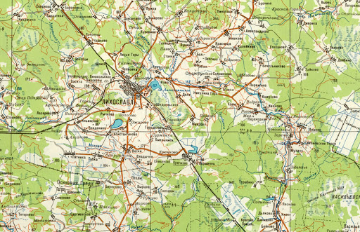
In the mapping world, Topographic maps are one of the oldest mapping methods that represent elevation information in contour line format, and it also shows natural & man-made features. In the early times, maps were published as in a series of the map. All the maps have to be combined to form a whole map. Today, Digital maps have taken over.
Let’s discuss the best digital topographic and historical maps you should know.
Digital Topographic Maps
1. OpenStreetMap
OpenStreetMap is a map of the world, free to use under an open license. It is a crowdsourced topographic map, public users can update the data in digital topo maps. It includes boundaries, cities, water features, physiographic features, parks, landmarks, transportation, and buildings & business tags.
2. Google maps
Google maps are the most powerful and updated topographic map, public users can update and edit the information with basic knowledge. Tt includes boundaries, cities, water features, physiographic features, parks, landmarks, transportation, and buildings. Here parallelly you can view the satellite images. It updates live traffic information and you can also load your local (kml/kmz) for analysis purposes. It is a frequently updated and a powerful map that shows business information tags for all over the world.
3. Esri World Topography
Esri world topographic map includes boundaries, cities, water features, physiographic features, parks, landmarks, transportation, and buildings. You can also load your local (kml/geojson file) for analysis purposes & customize your visualized maps and you can export and print your customized maps.
4. Bing maps
Microsoft added an OpenStreetMap layer to Bing Maps. Nokia powered many aspects of Bing Maps as an extension to its Windows Phone 7 partnership with Microsoft, including mapping data, geocoding, traffic data and navigation. Bing maps include administrative boundaries, cities, parks, landmarks, transportation and here live traffic data also viewed and you can customize your maps.
5. Here maps
Here maps include boundaries, cities, water features, physiographic features, parks, landmarks, transportation, and buildings along with navigation & online traffic data. It shows the building numbers for building features.
Historical Topographic Maps
1. Mapstor
Mapstor offers topographic maps issued by the military & state agencies of Europe, US, Russia in the 19 – 20 centuries. It provides georeferenced topographic maps. It gives the topographic maps coverage for google earth.
2. Omni Maps
Omni maps are owned by east view companies, it has over 200,000 map items. The map provides paper & digital maps for topographic maps, travel maps, city maps, road maps, wall maps, etc., for nearly all countries & regions of the world
3. USGS Topo view
USGS topo view includes a historical topographic map, it is available in different levels of detail and supports various land use and other purposes. Most of the current map of each area is available from the national map. It includes historical natural, cultural & geologic features have changed over time
4. Survey of India
The Survey of India offers topographic maps on various scales. It has also published an open series map that includes nautical and cartographic maps.
5. Australian Government – Geoscience Australia
Geoscience Australia is a pre-eminent public sector geoscience organization. It provides historical topographic maps on various scales(1:50 000, 1:100 000, 1:250 000 and 1:1 million scale Australian topographic maps.). You can download and print as you want. Also provides thematic maps(Includes railways, land tenure, maritime zones and more.)
6. Natural Resources Canada
Natural Resources Canada develops policies and programs that enhance the contribution of the natural resources sector to the economy, improve the quality of life for all Canadians and conduct innovative science. It provides lot of thematic and topographic maps for example – Wall maps, administrative, road, population, ground relief, driange, etc.,
7. Federal Agency for Cartography and Geodesy
Federal Agency for Cartography and Geodesy provides geodetic reference systems and geo topographic reference data for the territory of the Federal Republic of Germany and develop the necessary technologies.
Whether current or historical, topographical or thematic maps – in our extensive range of maps you will find products for almost every purpose. Small-scale maps map the entire federal territory and offer information on topography, administrative units, land cover or landscape structure.
With the regional maps and topographic maps on a medium scale, you can orientate yourself in your home region or plan your next trip. Historical topographic maps in medium and large scales are suitable as aids for teaching and research.
8. My topo
My topo is developed by Trimble, it provides professional & recreational topographic maps in addition to producing hundreds of custom topographic, satellite & aerial photographic map products. Maps are available in printed ,digital and online formats.
9. Perry-Castañeda Library Map Collection
The PCL Map Collection includes more than 250,000 maps, yet less than 20% of the collection is currently online. It provides historical maps for all over the world. And also have a collection of thematic maps, cartographic maps, nautical charts, weather map.
10. The Land Matters
The Land matters is a non-profit organization provides historical topographic maps and topographic maps, Geology, minerals, mines and agriculture maps.
Like to read more on GIS technology? Subcribe for weekly newsletter and stay updated!